Places to Visit
Colorado
New
Mexico
|
|

Story and photos by Kathryn Retzler
 The
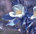
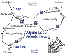
Alpine Loop The Alpine Loop is a
Scenic Byway, a special designation noted by signs showing the blue
Columbine, Colorado’s state flower. Unlike most byways, this one is a
rugged, four-wheel drive route over steep mountain passes. It follows
mining and stage trails laid out more than a century ago, and winds
through many ghost towns, past mining relics, cascading waterfalls,
fields of alpine wildflowers, and some of the most spectacular scenery
in the world! The
Alpine Loop The Alpine Loop is a
Scenic Byway, a special designation noted by signs showing the blue
Columbine, Colorado’s state flower. Unlike most byways, this one is a
rugged, four-wheel drive route over steep mountain passes. It follows
mining and stage trails laid out more than a century ago, and winds
through many ghost towns, past mining relics, cascading waterfalls,
fields of alpine wildflowers, and some of the most spectacular scenery
in the world!
Watch for
animals, too. Those little white dots on the mountainsides might just
be sheep. (This is still open range country.) Less easy to spot, but
there if you look closely, are Big Horn Sheep, wild goats, marmonts,
chipmunks, elk,
deer —
no, they don’t turn into elk in the fall — and all sorts of other
critters. You might even come across a “big kitty” or brown bear. Be
careful around all of them. This isn’t a zoo. Don’t get too close and
never try to pet wild animals.
Silverton. First known as
Baker’s Park, after the man who discovered this wide, flat valley
before the Civil War, the name was changed to reflect what came out of
the surrounding mountains — “Silver by the Ton!” At one time, the
town, located at 9,300 feet, boasted over 2,000 residents and was one
of the bawdiest, rowdiest mining towns in the San Juans. Today, it’s
tourists, not gold and silver, that go up and down the mountain on the
narrow gauge rails that have served the town for 120 years.nd silver,
that go up and down the
mountain on the narrow gauge rails that have served the town for 120
years.
Animas Forks. The town was laid out in
1877. By 1885 it was connected to Ouray, Lake City, and Silverton by
daily stages and by telephone lines running over Engineer Pass. In
1904, at 11,160 feet, Animas Forks boasted the highest railroad
in America. Many of the buildings still stand, including an old school
and the famous three-story Walsh House, owned by Thomas Walsh who
purchased the Hope Diamond for his wife.
Ouray. Appropriately
called the “Gem of the Rockies” and “Little Switzerland of America,”
the city of Ouray nestles in a steep v-shaped valley in the heart of
the San Juan Mountains. Surrounded by snowcapped peaks, several topping
14,000 feet, the jewel-like Victorian town, at 7,700 feet, is an
historical journey, a scenic feast. The town, like its loop neighbors
Silverton and Lake City, is designated a National Historic District.
Originally named Uncompahgre City, after the Ute word that means “hot
water springs,” the name was changed in honor of Ute Chief Ouray who
signed the Brunot Treaty, opening the San Juans to mining and
settlement.

Lake City. Named after Lake
San Cristobol, the second largest natural lake in Colorado, Lake City,
at 8,761 feet, is not the highest on the loop, but some say it is the
prettiest. Lake City also had the first telephone system in the state,
with connecting service to Silverton, Ouray, Capitol City, Rose’s
Cabin, Mineral Point and Animas Forks. Another first was a boisterous
Fourth of July Celebration, which soon became a big day for all mining
towns. The tradition continues today. |

 The
Alpine Loop The Alpine Loop is a
Scenic Byway, a special designation noted by signs showing the blue
Columbine, Colorado’s state flower. Unlike most byways, this one is a
rugged, four-wheel drive route over steep mountain passes. It follows
mining and stage trails laid out more than a century ago, and winds
through many ghost towns, past mining relics, cascading waterfalls,
fields of alpine wildflowers, and some of the most spectacular scenery
in the world!
